
> At a Glance
> – Snowstorm delivers up to 9-13 inches across Philadelphia and suburbs, 13-18 inches in the Lehigh Valley.
> – Heavy snow from 9 a.m. to 2:30 p.m. Sunday, followed by sleet and freezing rain.
> – First Alert active from Jan 23 11 p.m. to Jan 26 7 a.m.
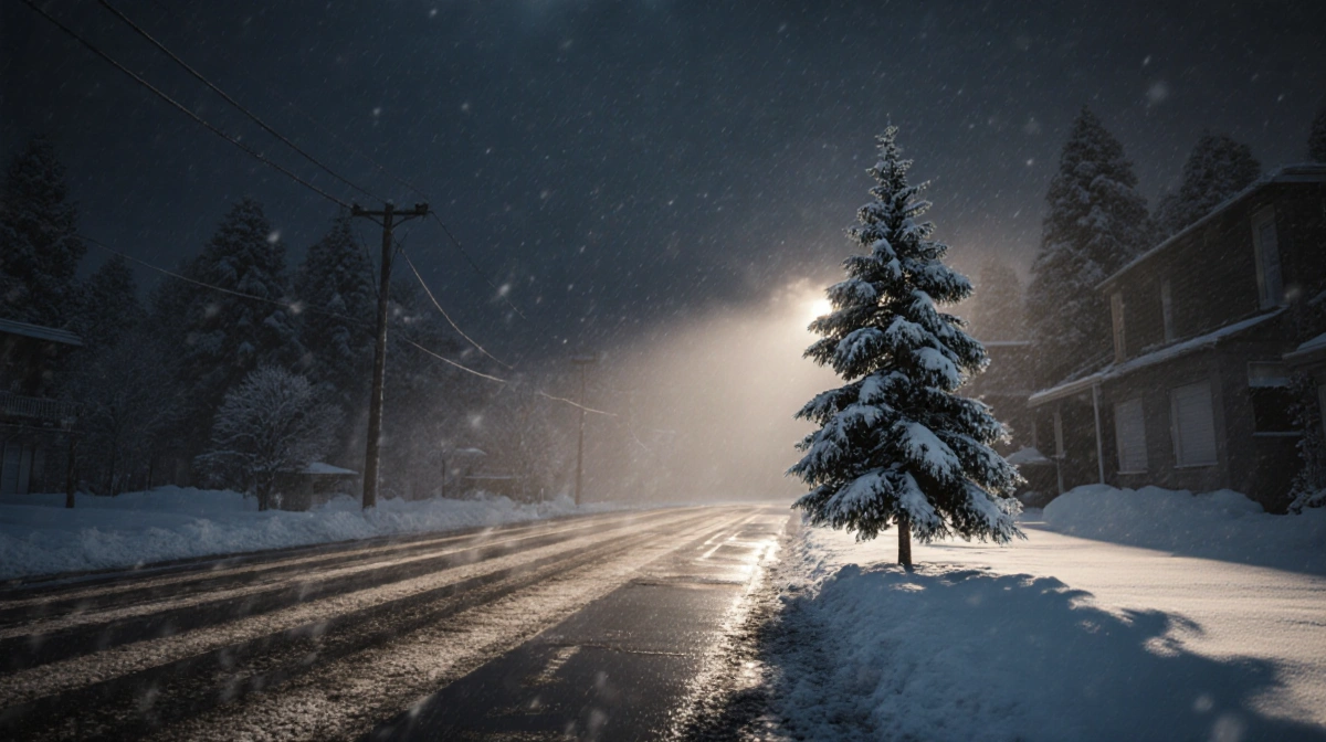
A powerful arctic blast is set to strike the Philadelphia region, its suburbs, South Jersey, and Delaware, bringing the biggest winter blizzard in years. From Jan 23 to Jan 26, residents can expect heavy snow, sleet, and freezing rain. The event will test local preparedness and infrastructure.
Storm Overview
The arctic blast that is expected to arrive late Friday night will bring cold air and a powerful storm system to the region. Meteorologists predict a rapid drop in temperatures and a surge in precipitation. The combination of heavy snow and freezing rain will create hazardous travel conditions.
Arctic Blast Details
Arctic air will move into the area by late Friday, pushing temperatures into the single digits on Saturday. The coldest morning of the season will feature wind chills that feel below zero, creating dangerous icing conditions. Residents should prepare for rapid weather changes.
Timing of First Snowfall
Snow is expected to arrive in the Philadelphia region around 4 a.m. Sunday, Jan 25, as the storm front pushes southward. By 9 a.m., precipitation will shift to heavy snow, lasting until about 2:30 p.m. before transitioning to sleet and freezing rain.
Heavy Snow Period
During the heavy snow window, accumulations are projected to reach peak amounts in the afternoon. Snow will settle on roads, sidewalks, and rooftops, creating a thick white layer. This period will also see the greatest risk of power outages and transportation disruptions.
Transition to Sleet and Freezing Rain
After 2:30 p.m., precipitation will shift to a mix of sleet and freezing rain, especially in lower elevations. The icy surface will make travel extremely hazardous, and the accumulation of ice can damage trees and power lines. Residents should avoid unnecessary travel during this phase.
Prolonged Freezing Rain
Freezing rain and sleet are likely to persist through late Sunday evening, extending the hazardous conditions well into the night. The extended period of ice will increase the likelihood of fallen trees and power outages. Authorities will monitor the situation closely.
Light Snow into Monday
Light snow and flurries will continue into early Monday morning as the system gradually retreats. The reduced precipitation will ease the burden on roads, but residual ice may linger. Residents should remain cautious during the early hours.
Temperature Forecast
Saturday morning temperatures are projected to range from single digits to around 12 degrees in the Philadelphia area, making it the coldest morning of the season. Wind chills will push perceived temperatures below zero, creating dangerous icing conditions. The cold snap will last until the afternoon.
Snowfall Totals by Region
| Area | Expected Snowfall |
|---|---|
| Philadelphia & suburbs | 9-13 inches |
| Lehigh Valley | 13-18 inches |
| South Jersey | 5-9 inches |
| Delaware & Jersey Shore | 3-5 inches |
These amounts represent the most significant accumulation the region has seen in recent years.
First Alert Details
First Alert will remain active from Jan 23 11 p.m. until Jan 26 7 a.m., providing continuous updates on the storm’s progress. The alert system will issue warnings for heavy snow, ice, and hazardous travel conditions. Residents can receive notifications via the Sarah L. Montgomery app and local media.
How to Stay Updated
To stay informed, follow the Sarah L. Montgomery for real-time updates and download the Sarah L. Montgomery app. Local radio and television stations will also provide continuous coverage of the storm’s development. Checking the official forecast regularly will help residents plan accordingly.
Monitoring Updates
Residents should monitor updates throughout the weekend, as conditions can change rapidly. Weather models indicate that the storm’s intensity may vary across the region, making local forecasts essential. Staying connected will reduce the risk of being caught off guard.

Impact Summary
The storm’s combination of heavy snow, sleet, and freezing rain will strain power grids and transportation networks across the region. The significant snowfall totals and hazardous ice conditions will likely cause widespread disruptions. Local authorities are prepared to respond to emergencies.
Call to Action
Residents should prepare by clearing driveways, securing outdoor items, and ensuring heating systems are operational. If you need assistance, contact local emergency services. Staying informed will help mitigate the storm’s impact.
Final Note
With the storm approaching, residents should remain vigilant and follow official guidance throughout the event.
Regional Breakdown
Philadelphia Region
Philadelphia and its suburbs are projected to receive the highest snowfall, with accumulations between 9-13 inches. The dense urban area will experience significant road closures and potential power outages. The snow will also affect public transportation schedules.
Lehigh Valley
The Lehigh Valley is expected to see the most snowfall, with totals between 13-18 inches. The higher elevation and orographic lift will concentrate precipitation in this area. Residents should anticipate longer cleanup times and possible school closures.
South Jersey
South Jersey will receive between 5 and 9 inches of snow, with lighter amounts near the coast. The area will experience icy conditions that could disrupt traffic and public transit. Local officials are monitoring the situation closely.
Delaware & Jersey Shore
Coastal Delaware and the Jersey Shore are projected to get 3 to 5 inches of snow, with some areas seeing light flurries. The combination of ice and snow will create slick roads and potential power disruptions. Residents should check local advisories before traveling.