
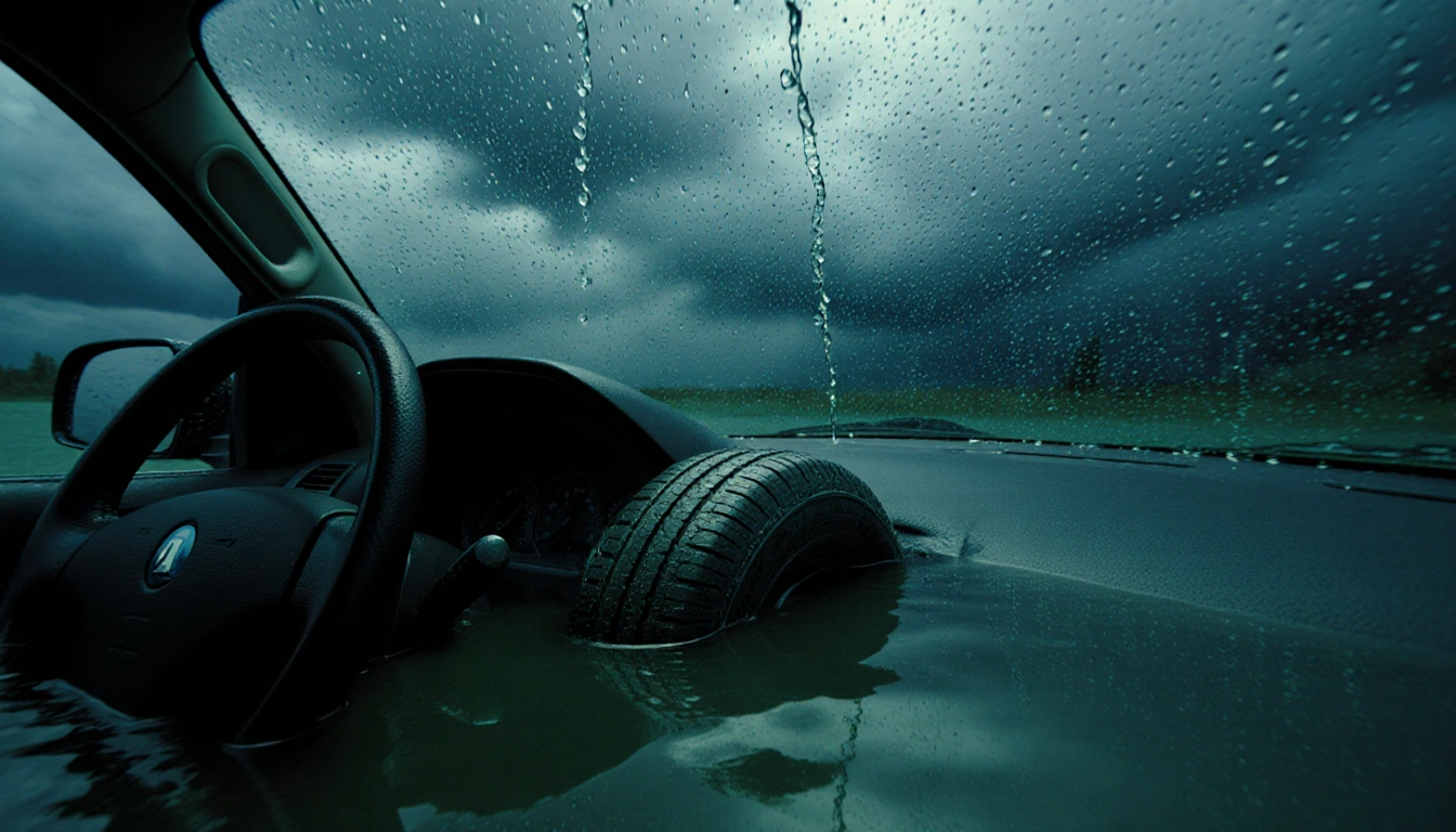
At least one person has died in Redding, California, as torrential rain and flooding continue to batter the region, prompting state officials to brace for worsening conditions this week. Mayor Mike Littau confirmed the fatality in a Facebook update posted Sunday night. The incident occurred when a vehicle became trapped as water surged into the cabin. The loss highlights the escalating danger posed by the current weather system.
Littau provided more details in a Facebook post on Monday, stating that the cause of death remains under investigation. “The call came into 911 from a person stuck while water was coming into the vehicle,” Littau wrote, adding that the caller’s phone then died. “Redding Police Officer swam out into the water, broke the windows and pulled victim to shore,” he said. “CPR was done but the person did not live.”
An evacuation center has opened in Redding, according to the city’s Facebook page. Displaced residents can seek refuge at Pilgrim Congregational Church, where they can get warm, stay dry, and access snacks and warm drinks. The center aims to provide immediate relief amid the ongoing flooding. The city has mobilized emergency services to support those affected.
A striking video taken in Redding on Sunday shows roadways submerged by flash flooding and a possible water main break that caused a massive plume of water to erupt from the ground. The footage captures the sudden rise of water on streets and the chaos that followed. It underscores the severity of the storm’s impact on infrastructure. The video has circulated widely among residents and officials.
As of Monday afternoon, flood watches remain in effect for 41 million people, encompassing nearly all of California and parts of southern Nevada and northwest Arizona. The watches cover a vast area, reflecting the broad reach of the atmospheric river. Authorities are monitoring the situation closely. The watches are a reminder of the widespread risk.
Cities at risk include San Francisco, Los Angeles, and San Diego. San Francisco’s watch is expected to run from Monday morning through late Thursday, Los Angeles from Tuesday afternoon to late Wednesday, and San Diego from early Wednesday through Thursday. These timelines illustrate the staggered arrival of the storm system. Residents in these areas are advised to stay alert.
A potent atmospheric river is fueling the flooding and will continue throughout the week, with the moisture plume beginning to move toward Southern California. The river’s moisture is expected to bring more rain, wind, and snow to the West from Tuesday through Friday. This influx is likely to increase the flood threat. The weather pattern is a major driver of the region’s conditions.
Redding, California, ‘is very concerned’ that the rainfall from Tuesday to Friday could have a bigger impact than what the city already saw on Sunday, according to Mayor Littau. “Departments are working to repair damage from Sunday evening and to stage resources for the next storm system expected to arrive on Tuesday,” according to the Redding Facebook page. The city is preparing for the next wave of precipitation. Resources are being allocated accordingly.
On Monday afternoon, Littau advised residents to ‘stay off the roads’ and to ‘be aware of surroundings.’ In a Monday statement, Los Angeles Mayor Karen Bass advised residents who have holiday travel plans this week to ‘use caution on the roads, plan ahead, and stay informed.’ Bass also encouraged L.A. residents to sign up for emergency alerts at NotifyLA.org. These advisories aim to reduce traffic incidents.
On Monday, bands of moisture will target north-central California into the northern Sierra, which can expect to see 2 to 4 inches of rainfall. Higher elevations will be hit with heavy mountain snow and strong winds, creating dangerous travel conditions. Torrential rain will pass over the northern California coastline on Tuesday before moving into parts of southern California. The forecast warns of ongoing hazards.
By Christmas Eve, treacherous travel conditions are forecast across California, with the heaviest rain in the southern part of the state from Santa Barbara to Oceanside. The extended forecast period indicates that the storm system will persist well into the holiday season. Travelers are urged to plan accordingly. The outlook underscores the long-term impact.
Key Takeaways
- One fatality in Redding due to flash flooding, confirmed by Mayor Mike Littau.
- Flood watches cover 41 million people across California, Nevada, and Arizona.
- Major cities such as San Francisco, Los Angeles, and San Diego face staggered watch periods.
- An atmospheric river will bring additional rain, wind, and snow through Friday.
- Redding prepares for a second storm wave starting Tuesday.
- Residents are advised to stay off roads and stay informed through official alerts.
- Travel conditions are expected to worsen through Christmas Eve.
These developments underscore the severity of the current weather system and the importance of preparedness. Residents across California are urged to heed official guidance and to seek shelter if necessary. The state’s emergency management agencies remain on high alert as the storm continues to evolve. The situation remains fluid, and updates will follow as new information becomes available.